CyberGeologist
Seeing Into the Past
How can you look thousands of meters below the surface of the Earth or see millions of years into the past? Scientists use everything from picks and shovels to high-powered computers to study rock formations deep below the Earth's surface in the search for oil and gas. A variety of methods are used to "see" these formations, from studying rocks on the surface to creating three-dimensional (3-D) computer models of ancient landscapes buried deep underground. During the 1990s, many companies were beginning to develop software to create these views into the Earth's geologic formations. Technoguide designed a software program that let users create an image of underground geologic rock layers on a computer without having to know any computer code. The company called this software “Petrel,” and it was first released to the public in 1998. Schlumberger purchased Technoguide in 2002. Since then Petrel has become the flagship software program for Schlumberger; it is used by companies worldwide. The software program GeoFrame also was used by Schlumberger in the first days of computer-built geologic imaging.
The CyberGeologist Research Program
|
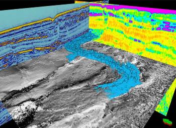
A 3-D computer model of an underground gas reservoir shows rock formations in prehistoric rivers. The image was created using the Petrel software program. |
In the 1990s a research program was created to develop software that could store and analyze all kinds of data about underground rock formations in order to generate 3-D models of what was below the surface. The thought behind this idea was that with additional combined information, geologists could more accurately predict how much oil and gas were stored in the rock layers. The program, sponsored by Schlumberger and the United States Gas Research Institute, was called CyberGeologist. The scientists working on it were based in Connecticut, in the United States, but their study looked at formations of all ages from all over the world.
The researchers used two different approaches. By looking at samples of rocks from deep below the surface, they studied ancient rock formations that were formed hundreds of thousands of years ago. In addition, to better understand the shapes of ancient rock formations underground, they studied sedimentary formations as they were developing in rivers and streams. This understanding was then used to help create more accurate models of oil and gas reservoirs below the surface. The scientists then took all this information and put it into a computer using the software program GeoFrame. Their approach to modeling underground geology was so new and creative that the methods were patented in 1997. Not only was this patent very important, but also the additions to the GeoFrame software that developed during this time are still used worldwide today
One type of sand body that the scientists studied is called a point bar. Read on to learn more about how point bars are formed and how understanding them has helped scientists learn to "see" below the surface of the Earth.
This content has been re-published with permission from SEED. Copyright © 2025 Schlumberger Excellence in Education Development (SEED), Inc.


