Global Climate Change and Energy The Impact of Global Warming
Over the past 425,000 years the Earth has gone through four ice ages punctuated by brief warm periods. We are currently in such a warm period. The trend over the past century has been one of generally rising global temperature. The consensus among climatologists is that there will be a continued increase during the rest of this century. OK. But is this a problem? Yes it is. Even though there might be a few benefits of warming, such as longer growing seasons in some cooler agricultural areas, the consequences for most people in most parts of the world will be negative. Here are some of the problems.
Sea Level Changes
At the height of the last ice age 18,000 years ago, the oceans were about 120 m (400 ft) lower than they are today. Large amounts of water were sitting on land in the form of glaciers that covered a good portion of North America, Europe, and Asia.
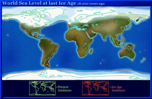
The North Sea and the Baltic Sea were mostly land. The Bering Strait that now separates Siberia from Alaska was also above sea level. It is believed that people walked across this land bridge and populated the Americas for the first time in human history.
As the ice age ended, the glaciers mostly melted and their water returned to the oceans. Sea levels rose. Another factor affecting sea level is the temperature of the water. Water, like most substances, expands as it is warmed. The expanded seawater has a larger volume, which contributes to rising seas.
|
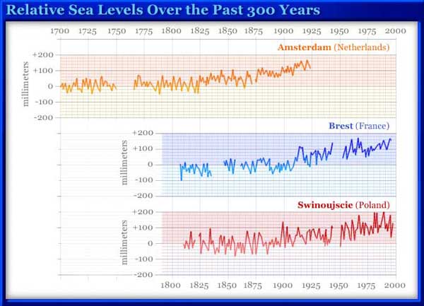
Image based on data from the Intergovernmental Panel on Climate Change (IPCC) |
If we look at the recent past, we see a continuing rise in sea levels. The chart shows sea levels at three locations in Europe over the past 300 years. During this period sea level has risen 100 mm (3.9 in) or more. But the rise in sea level is not the same in all parts of the world. In some places, sea level is actually falling, as shown in the map World Sea Level Rise and Fall.
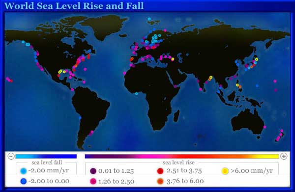
This may sound strange. If all the oceans are connected, how can the level be different from one place to another? Actually it can. Sea level is locally affected by currents, winds, rate of flow of water from land into the oceans, air pressure, and tides. But mostly, it is because of our definition of sea level. We are measuring “relative sea level,” that is, the level of the sea relative to nearby land. Land may be rising or falling. For example, the area around the Mississippi Delta, where the river empties into the Gulf of Mexico, is subsiding. The land is made of recently deposited sediments that are settling. Many areas that were covered by the glaciers of the last ice age are rising since the weight of the ice has been lifted. Places on the southern coast of Alaska are experiencing a falling sea level. This is also true of many ports in Scandinavia.
More than 100 million people live on land within 1 m (3 ft) of sea level. Some island countries such as the Seychelles off the east coast of Africa are mostly less than 1 m above sea level. It is estimated that a rise of 1 m would put half of the land of Bangladesh under water. Although there are local variations in sea level, the key question is what is happening to the volume of ocean water worldwide. The major determining factor is the amount of water in glaciers on land, especially in Greenland and Antarctica.
What Will Happen Next?
While the ice-age glaciers have mostly retreated, Greenland and Antarctica remain covered with ice that is 2,000 to 4,000 m (6,550 to 13,000 ft) thick. The fate of these ice packs will have a significant impact on future sea levels. The Intergovernmental Panel on Climate Change (IPCC) reported in 2001 that it expects a rise in sea level by 2100 of up to 66 cm (26 in) due to glacier melting. In a 2002 report researchers at the University of Colorado, USA, analyzed the rate of melting of glaciers around the world. They calculated that glaciers are melting faster than previously thought and that by 2100 the sea level could rise by as much as 89 cm (35 in). But more recent studies raise questions about these predictions. Two studies reported in 2005 show that during the period from 1992 to 2003, snowfall increased over large portions of the interiors of Antarctica and Greenland. The glaciers are melting at the edges, but they are thickening in the interior. The question is how these contradictory tendencies will balance out.
|
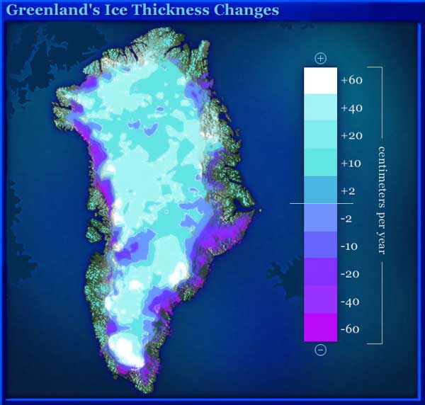
This satellite image of Greenland shows changes in ice thickness. The blue areas are thinning. The gray and yellow areas are thickening. The rough gray areas at the edges of the landmass are not covered by the glacier. The image is based on satellite surveys of Greenland made during the 1990s. This study by NASA indicates a net loss of Greenland ice, but a 2005 study by a team of researchers led by Ola M. Johannessen of the University of Bergen, Norway, found that the thickening of the ice cap away from the edges was great enough so that there is a net gain in ice volume from year to year. But even more recent studies indicate that there is now a net loss of ice mass from year to year. |
|
Photo by Ben Holt, Sr. courtesy of NASA Antarctic ice |
A special report in the March 24, 2006, issue of Science includes several studies that point to an increasingly rapid loss of the world's ice sheets. In particular, it has been found that the movement of Antarctic and Greenland glaciers toward the sea is accelerating. This will certainly result in quicker loss of these ice caps and consequently more rapidly rising sea levels.
Precipitation Changes
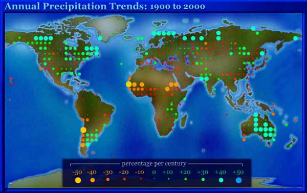
Over the last 100 years many dry areas have become even drier and wet areas have become wetter. Many long-standing weather records have been broken in recent years. In 1992, the Danube and Elbe rivers burst their banks in central Europe. The southern section of the Sahara desert suffered a serious, long-lasting drought in the 1990s. Droughts affect different parts of the western United States each year. In some locations the drought may last more than a year.
|
Image based on data from the Intergovernmental Panel on Climate Change (IPCC) |
Tropical Storms
Tropical storms form over warm ocean waters near the equator. Warmer water results in more storms and more intense storms. In recent years there has been an increase in both the number and severity of tropical storms. The 2005 Atlantic hurricane season was particularly devastating, with three major storms—Katrina, Rita, and Wilma—causing extensive damage in the United States and Mexico.
The season for Atlantic tropical storms is considered to be from June through November. But in 2005, Tropical Storm Zeta, the final storm of the season, formed in late December and lasted into January 2006. It is tempting to attribute the increase in storm activity to rising global temperatures. This may be the case, but the situation is more complicated. There have been cycles of storm intensity and frequency in the past. The 1930s through the1950s were a period of greater storm activity. This was followed by several decades of relative calm and then the period of increased activity that we are currently experiencing. These cycles are due to changes in rainfall, ocean currents, and salinity. So there are two tendencies, one cyclical and the other long-term. Even if storm activity ebbs and flows as it has in the past, warmer oceans are likely to result in more storms and more intense storms. The quiet parts of the cycle will not be as calm as in the past. The active periods are likely to be worse. People in some parts of the world are in particular danger from storms in combination with rising sea levels. The Gulf of Mexico and the Bay of Bengal are places where relative sea level is rising most rapidly. They are also subject to frequent tropical storms.
Can Global Warming Cause Cooling?
While many parts of the world can expect warmer weather, global warming might have the opposite effect in some places. Western Europe is quite warm for its latitude. This is because the Gulf Stream, a warm ocean current, reaches into the North Atlantic. Winds passing over the warm water and onto land have a moderating effect on the climate. For example, the average winter temperature in London, England, is about 4°C (39°F). Calgary, in western Canada, is at about the same latitude but has an average winter temperature of -9°C (16°F). The Norwegian port of Tromso and the Russian port city of Murmansk are ice-free year round even though they are in the Arctic. The Gulf Stream is part of a worldwide circulation of ocean water known as the thermohaline circulation. Thermo refers to temperature and haline to salinity. Temperature and salinity both affect the density of water.
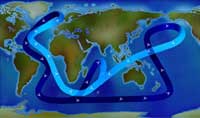
Thermohaline circulationImage courtesy of NOAA. This is a simplified diagram of the global thermohaline circulation. Surface currents carry warm water, while deep currents are cold. The warm current that reaches into the North Atlantic is called the Gulf Stream. It is responsible for keeping western Europe relatively warm. Click for animation. |
As the Gulf Stream waters flow northward, water evaporates. This causes an increase in salinity because the same amount of salt is now held by less water. At the same time, the waters cool.
Increased salinity and decreased temperature both result in the water becoming denser. The denser water sinks and flows south. What does this have to do with global warming? The melting of Arctic ice is adding fresh water to the North Atlantic. This means that the waters at northern latitudes are becoming less dense and therefore less prone to sinking. The result could be a decrease in the rate of flow of the currents. A reduced Gulf Stream flow would have less of a warming effect on western Europe. There have been some predictions that the thermohaline circulation could shut down suddenly, causing a temperature drop of about 8°C (14°F) in western Europe in a matter of a few decades. Most climatologists think this is very unlikely. However, there could be a slowing of the circulation resulting in some cooling effect. But since global temperature is rising, the net effect may be that western Europe stays the same, or gets just a bit warmer. Since climate is very complicated, it is difficult to make accurate predictions. Specific tendencies are known, but how they interact with each other is less certain.
What Can We Expect?
The world's climate system is complicated. It is difficult to make precise predictions. But the future trends are becoming increasingly clear: rising sea levels, more frequent and more intense storms, and increased drought in many already dry parts of the world.
This content has been re-published with permission from SEED. Copyright © 2025 Schlumberger Excellence in Education Development (SEED), Inc.


