
Water Source—Habitat Complexity
Biodiversity, which is defined by the variety of organisms, is a universal indicator of an ecosystem's health. To accommodate a diverse animal community, the stream or pond needs to offer a wide variety of habitat opportunities.
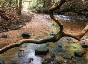 The key to influencing habitats in streams is roughness, which means everything that gets in the way of the water as it flows downstream. The size of the stream therefore becomes an issue. The habitat complexity score will be higher if there is more flow, because more energy is available to create larger and more complex habitats. However, if your stream gets a low score, it might not mean that complexity is low, it simply means that you need to compare that score with that of an undisturbed reference site within the watershed.
Ponds are similar in their need for habitat complexity. The focus for habitat complexity is near shore areas and the comparison to similar reference locations.
Equipment
- pond or stream scoring sheet
- landowner's permission
Investigation: Estimate the number of distinct habitat types found
Stream: Hydraulic head is the difference between the front and back of a ruler in mm (in) height in the water with the wide edge facing the current. Find the depth and the hydraulic head at each point on the stream edge.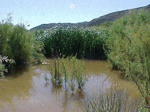
Pond: For each site in the survey where there is an area of interest, an additional reference site must also be examined. Mark 1-m (3-ft) and 5-m (16-ft) intervals with different colors along a rope, attach an anchor to one end, and begin at the shoreline. From along your shore transect line you'll be making 90° angles from the shore to where you can no longer see the bottom of the pond. The length of this transect depends on shoreline slope. On steep slopes, only extend the transect out to the 1-m mark. On gentler slopes, sample to a distance of 20 m (65 ft) out from shore (to where you can no longer see the bottom). Observe habitat conditions 1-m either side of transect line.
Record data for each transect:
- number of logs/trees touching the transect line. A log must be at least 10 cm (4 in) wide at some point and at least 1 m long to count.
- number of large materials such as boulders, cribs, docks, etc. You may wish to keep track of the materials in a comments section.
- list of aquatic vegetation types: submergent (below the surface), floating, and emergent (extending above water)
- percent of pond bottom obscured by vegetation, exposure to wave action, and shoreline slope
Summerize the data in the reference location and the area of concern by grouping the data into pairs with similar exposure and shore slope.
Scoring for stream
| # of habitat types | Grade | Comment |
|---|---|---|
| more than 10 | A | Rough channel, complex habitat opportunities available |
| 8 to 9 | B | |
| 6 to 7 | C | Coarse channel, some habitat opportunities available |
| 4 to 5 | D | |
| 3 or less | E | Simple channel, habitat opportunities are rare |
Scoring for pond
| Difference in scores | Grade | Comment |
|---|---|---|
| less than 2 | A | Well vegetated, good buffering and connections |
| >/=2 but less than 4 | B | |
| >/=4 but less than 6 | C | Patchy or diminished vegetation, some buffering and connections |
| >/=6 but less than 8 | D | |
| >/=8 | E | Absence of vegetation, little buffering, poor connect |
This content has been re-published with permission from SEED. Copyright © 2026 Schlumberger Excellence in Education Development (SEED), Inc.