
Virtual Reality In The Oil and Gas Industry

Using Virtual Reality (VR), an earth scientist can "dive" under the surface and "fly” around the reservoir, detecting interesting features in the data that would be less obvious on a small desktop computer monitor: he can quickly turn himself into a giant and examine horizons which span for kilometers, or become a Lilliputian and zoom in on microscopic pores around a wellbore. Several different experts can gather in a room with a large screen and study alternative interpretations. In fact, these experts don't even have to be in the same room physically, since some VR systems enable geographically distributed asset teams to collaborate at a distance.
Valery Polyakov
Senior Research Associate
 This image is generated from data gathered inside the 20-centimeter diameter borehole of an oil well. |
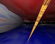 Here we see the borehole image within the surrounding geological formation. This is a visual representation of the underground, which we can see and move around in using Virtual Reality |
People who work in the oil industry, such as geologists, geophysicists and reservoir engineers like to work with 3D models of the reservoir they are studying. These models, which are often very large and complex, are constructed using information from many different sources: seismic data, which reveals structural features such as faults or horizons on a scale of tens to thousands of meters; and well logs, which yield local information around the wellbore about the porosity, permeability and other properties of the rock.
Using powerful graphics workstations in conjunction with VR techniques, a geologist can manipulate, interrogate and investigate a large reservoir model containing all these different data types more easily. VR also accelerates the pace of discovery, improves communication, reduces the risk of error and makes the decision making process more efficient.
This content has been re-published with permission from SEED. Copyright © 2026 Schlumberger Excellence in Education Development (SEED), Inc.