Earthquakes and Man-Made Shocks Taking the Earthquake Trail
The catastrophe known as the “The Great San Francisco Earthquake of 1906” launched the serious study of earthquakes and the geology of California. Many articles and papers have been written about the San Andreas Fault System, a part of which was shaken by the earthquake. Together these articles form a body of knowledge which helped lead to the theory of plate tectonics.
The 1906 earthquake was a result of transform plate movement. This occurs when tectonic plates move sideways and rub against each other. The earth shook for about a minute on April 18, 1906 at 5:12 in the morning. It measured about 7.8 on the Richter Scale. The damage was devastating. More than 3,000 people were killed and many thousands were injured by the quake and resulting fires.
|
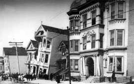
Photo courtesy USGS Ground subsidence in bay mud, 18th and Howard Streets, San Francisco — a classic photo, showing the result of building on bay mud, which becomes unstable during earthquakes. Any houses currently sitting on this type of landfill are still vulnerable. |
Thousands of small, imperceptible earthquakes occur in the Bay Area each year. Only a handful make local news. However, in the period from 1800 to the present, the San Francisco Bay region has been shaken by 21 earthquakes measuring 6.0 or higher on the Richter Scale.
Point Reyes, just north of San Francisco, is one of the best places to actually see the San Andreas Fault — and the impact of the 1906 earthquake. A walk along the Earthquake Trail in the Point Reyes National Seashore gives visitors a chance to examine the remaining traces of the great quake, see the history in pictures and read some of the personal stories — real and imagined — of those living in Point Reyes at the time.
|
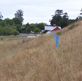
Photo by Suzy Gazlay Blue posts mark the line of the fracture that is shown in newspaper photograph (right) near Point Reyes park headquarters. |
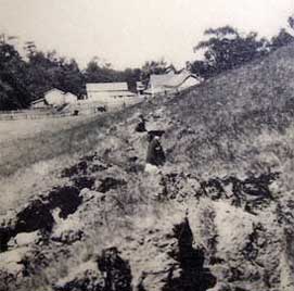
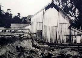
Photo courtesy USGS One of the barns in the background survived the earthquake. It is now used for programs at the park headquarters. |
|
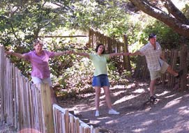
Photo by Suzy Gazlay An old wooden pasture fence still has a 5.5 meter (18 foot) break where the earth moved. |
Photo courtesy USGS This is the same barn shown above just after the earthquake with the crevice running right underneath it. |
|
Photo courtesy USGS The site of the greatest displacement that was measured during the 1906 Earthquake – Sir Francis Drake Boulevard – is still in use, connecting the towns of Point Reyes Station and Inverness. The 20-foot shift caused the road to be discontinuous. |
|
Photo courtesy USGS Town of Point Reyes Station,1906 |
|
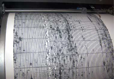
Photo by Suzy Gazlay. Working seismograph located at the Point Reyes National Seashore headquarters. The electronic impulses are being transmitted from a sensor buried underground somewhere out behind the visitor center. When this photo was taken, there had been some shaking a little earlier. It looks impressive, but it wasn’t strong enough to feel anything. Not everyone reads the explanation posted with the seismograph display, which tells you that the sensors are located outside and underground. It’s kind of funny to watch people jump up and down in front of the seismograph trying to make it record the shaking of the floor. |
The Story of the Fallen Cow
Signs along the trail at Point Reyes also explain the legend of Matilda the cow, who was supposedly swallowed by the crack that opened up in the earth. After the quake caused ferocious fires 35 miles away in San Francisco, it took a few days for reporters to find their way to the sleepy hamlet of Olema. When they arrived, they were led to a gaping hole where Matilda lay upside down.
It was a good story, with headlines shouting, "Fault swallows cow whole." However, locals whispered that a farm boy was having fun with reporters from the big city. It seems that Matilda had died of natural causes and the hole seemed a convenient place to bury her.
Here is the story according to the official report (G.K. Gilbert, US Geological Survey Geologist in Report of the State Earthquake Investigation Commission, 1908):
“In this connection mention may be made of the fact that at the Shafter Ranch a fault crevice was momentarily so wide as to admit a cow, which fell in head first and was thus entombed. The closure that immediately followed, left only the tail visible …at the time of my visit the tail had disappeared being eaten by dogs, but there was abundant testimony to substantiate the statement. At this point the fault trace was a trench 6 or 8 feet wide, and the general level of the soil blocks within it was 1 or 2 feet below that of the adjacent undisturbed ground.”
Here is the “unofficial” story, recalled by H.H. Howard, whose family owned the ranch in the pictures above. He describes a conversation he overheard as a boy in 1912:
“… In all events, there sat [my cousin] Payne astride his horse facing us, his hat down over his eyes, and Father and I on the bench there [by the barn]. The two men talked briefly and then for no reason I can remember my father said to Payne, I paraphrase, “Payne, why on earth did you tell those reporters that your cow was swallowed up by the crack in the earth?” To which Payne replied, I again paraphrase, 'Look, Pax, the cow had died, and we had to bury her. That night along came the earthquake which opened up a big crack in the ground; we simply dragged the carcass over to the crack and tipped it in, with the feet sticking out. Then along came those newspaper reporters and when they got the idea that the cow had fallen in, we weren’t about to spoil a good story. Why spoil it now?'“
This content has been re-published with permission from SEED. Copyright © 2025 Schlumberger Excellence in Education Development (SEED), Inc.


